Geolocate

Matawe topographic map

Click on the map to display elevation.

About this map

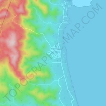
Name: Matawe topographic map, elevation, terrain.

Location: Matawe, Dingalan, Aurora, Central Luzon, 3207, Philippines (15.29551 121.34838 15.33551 121.38838)

Average elevation: 80 m

Minimum elevation: 0 m

Maximum elevation: 336 m

Other topographic maps

Click on a map to view its topography, its elevation and its terrain.

Umiray River

Philippines > Aurora > Dingalan > Abungan

Average elevation: 93 m

Dingalan River

Philippines > Aurora > Dingalan

Average elevation: 188 m

Gear up for your next adventure:

🔪Outdoor Multitool - Versatile tool for repairs and food prep in the wild
🧥Ultralight Puffy Jacket - Maximum warmth that packs down to the size of an orange
🧼Biodegradable Camp Soap - Environmentally friendly cleaning for gear and body
🛰️Satellite Messenger - Emergency communication for areas with no cell service
🌬️Windproof Camp Stove - Efficient cooking even on exposed mountain peaks

As an Amazon Associate, this site earns from qualifying purchases at no extra cost to you.