Geolocate

Mahabad topographic map

Click on the map to display elevation.

About this map

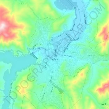
Name: Mahabad topographic map, elevation, terrain.

Location: Mahabad, بخش مرکزی مهاباد, Mahabad County, West Azerbaijan Province, Iran (36.72923 45.69726 36.80731 45.77217)

Average elevation: 1,445 m

Minimum elevation: 1,300 m

Maximum elevation: 1,921 m

Other topographic maps

Click on a map to view its topography, its elevation and its terrain.

Gear up for your next adventure:

🧥Thermal Layer - Insulating layer for cold outdoor conditions
🧊Portable Cooler - Keep food and drinks cold during outdoor adventures
🥾Waterproof Hiking Shoes - Durable shoes for wet and rugged trails
🧦Merino Wool Socks - Moisture-wicking comfort for long-distance hiking
🥾Trekking Poles - Adjustable trekking poles to reduce knee stress and improve stability

As an Amazon Associate, this site earns from qualifying purchases at no extra cost to you.