
Thank you for supporting this site ❤️
Make a donation
Make a donation
Gear up for your next adventure:
As an Amazon Associate, this site earns from qualifying purchases at no extra cost to you.
Folgosinho topographic map
Click on the map to display elevation.
Thank you for supporting this site ❤️
Make a donation
Make a donation
Gear up for your next adventure:
As an Amazon Associate, this site earns from qualifying purchases at no extra cost to you.
About this map
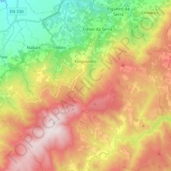
Name: Folgosinho topographic map, elevation, terrain.
Location: Folgosinho, Gouveia, Guarda, 6290-081, Portugal (40.44278 -7.53912 40.54850 -7.43426)
Average elevation: 947 m
Minimum elevation: 360 m
Maximum elevation: 1,594 m
Thank you for supporting this site ❤️
Make a donation
Make a donation
Gear up for your next adventure:
As an Amazon Associate, this site earns from qualifying purchases at no extra cost to you.