Geolocate

Weener topographic map

Click on the map to display elevation.

About this map
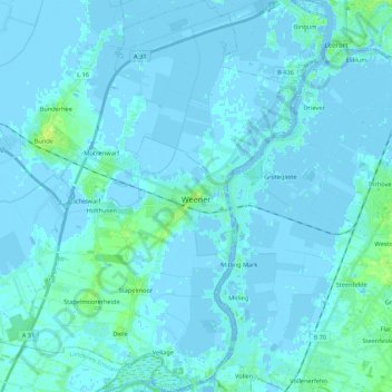
Name: Weener topographic map, elevation, terrain.

Location: Weener, Landkreis Leer, Nedersaksen, 26826, Duitsland (53.10099 7.24623 53.23047 7.41179)

Average elevation: 1 m

Minimum elevation: -6 m

Maximum elevation: 11 m

Other topographic maps

Click on a map to view its topography, its elevation and its terrain.

Ödenfeld

Duitsland > Nedersaksen > Landkreis Leer > Weener > Holthusen

Average elevation: 3 m

Wymeer

Duitsland > Nedersaksen > Landkreis Leer

Average elevation: 1 m

Stapelmoor

Duitsland > Nedersaksen > Landkreis Leer > Weener

Average elevation: 3 m

Bunderhee

Duitsland > Nedersaksen > Landkreis Leer

Average elevation: 1 m

Gear up for your next adventure:

🧥Ultralight Puffy Jacket - Maximum warmth that packs down to the size of an orange
🕶️Polarized Sunglasses - Reduces glare from snow and water at high elevations
🥾Hiking Boots - Sturdy boots providing ankle support and traction on rugged trails
🛶Kayak Accessories - Essential gear for safe and fun kayaking adventures
🧼Biodegradable Camp Soap - Environmentally friendly cleaning for gear and body

As an Amazon Associate, this site earns from qualifying purchases at no extra cost to you.