
Make a donation
Gear up for your next adventure:
As an Amazon Associate, this site earns from qualifying purchases at no extra cost to you.
Geishouse topographic map
Click on the map to display elevation.
Make a donation
Gear up for your next adventure:
As an Amazon Associate, this site earns from qualifying purchases at no extra cost to you.
About this map
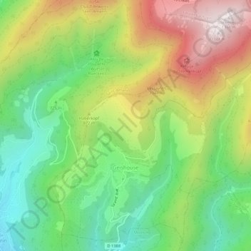
Name: Geishouse topographic map, elevation, terrain.
Average elevation: 799 m
Minimum elevation: 408 m
Maximum elevation: 1,346 m
Make a donation
Gear up for your next adventure:
As an Amazon Associate, this site earns from qualifying purchases at no extra cost to you.
Other topographic maps
Click on a map to view its topography, its elevation and its terrain.
Ballon d'Alsace
Frankrijk > Grand Est > Haut-Rhin > Sewen
De weg, die het Moezeldal in het noorden met het dal van de Savoureuse in het zuiden en de Doller in het oosten verbindt, voert op 1171 meter hoogte langs de top over een pas.
Average elevation: 994 m
Make a donation
Gear up for your next adventure:
As an Amazon Associate, this site earns from qualifying purchases at no extra cost to you.