
Make a donation
Gear up for your next adventure:
As an Amazon Associate, this site earns from qualifying purchases at no extra cost to you.
Herat Province topographic map
Click on the map to display elevation.
Make a donation
Gear up for your next adventure:
As an Amazon Associate, this site earns from qualifying purchases at no extra cost to you.
About this map
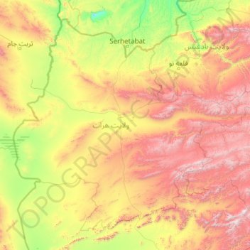
Name: Herat Province topographic map, elevation, terrain.
Location: Herat Province, Afghanistan (32.84981 60.51760 35.62560 64.47589)
Average elevation: 1,295 m
Minimum elevation: 315 m
Maximum elevation: 3,954 m
Make a donation
Gear up for your next adventure:
As an Amazon Associate, this site earns from qualifying purchases at no extra cost to you.
Other topographic maps
Click on a map to view its topography, its elevation and its terrain.
Kandahar
Afghanistan > Kandahar Province > Kandahar
Kandahar (English: /ˈkændəhɑːr/; Pashto: کندهار, romanized: Kandahār; Dari: قندهار, romanized: Qandahār) is a city in Afghanistan, located in the south of the country on the Arghandab River, at an elevation of 1,010 m (3,310 ft). It is Afghanistan's second largest city after Kabul, with a…
Average elevation: 1,048 m
Make a donation
Gear up for your next adventure:
As an Amazon Associate, this site earns from qualifying purchases at no extra cost to you.