
Make a donation
Gear up for your next adventure:
As an Amazon Associate, this site earns from qualifying purchases at no extra cost to you.
Villac topographic map
Click on the map to display elevation.
Make a donation
Gear up for your next adventure:
As an Amazon Associate, this site earns from qualifying purchases at no extra cost to you.
Villac
L'altitude minimale avec 126 mètres se trouve localisée à l'extrême sud, près du lieu-dit Muratel, là où l'Elle quitte la commune et entre sur celle de Beauregard-de-Terrasson. L'altitude maximale avec 330 mètres est située à l'est, près du lieu-dit Brolaud, en limite de la commune de Brignac-la-Plaine. Au niveau géologique, le sol se compose essentiellement d'argile ou de grès permiens.
Make a donation
Gear up for your next adventure:
As an Amazon Associate, this site earns from qualifying purchases at no extra cost to you.
About this map
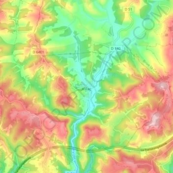
Name: Villac topographic map, elevation, terrain.
Average elevation: 229 m
Minimum elevation: 131 m
Maximum elevation: 333 m
Make a donation
Gear up for your next adventure:
As an Amazon Associate, this site earns from qualifying purchases at no extra cost to you.