Geolocate

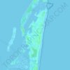
Canet topographic map

Click on the map to display elevation.

About this map
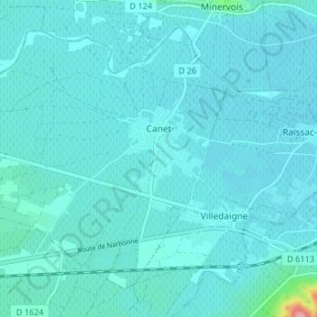
Name: Canet topographic map, elevation, terrain.

Location: Canet, Narbonne, Aude, Occitania, Metropolitan France, 11200, France (43.20506 2.79639 43.24451 2.86167)

Average elevation: 28 m

Minimum elevation: 18 m

Maximum elevation: 137 m

Other topographic maps

Click on a map to view its topography, its elevation and its terrain.
Pech d'Aspe

France > Occitania > Aude > Mas-des-Cours

Average elevation: 349 m

Cervière

France > Occitania > Aude > Armissan

Average elevation: 94 m

La Gare

France > Occitania > Aude > Villeneuve-la-Comptal

Average elevation: 220 m

La Franqui

France > Occitania > Aude > Leucate

Average elevation: 15 m

Saint-Pierre-la-Mer

France > Occitania > Aude

Average elevation: 20 m

Port-Leucate

France > Occitania > Aude > Leucate

Average elevation: 0 m

Le Castelas

France > Occitania > Aude > Rennes-le-Château

Average elevation: 381 m

Pic de Nore

France > Occitania > Aude > Pradelles-Cabardès

Average elevation: 1,063 m

Bourdials

France > Occitania > Aude > Castans

Average elevation: 745 m

Pech d'Aspe

France > Occitania > Aude > Mas-des-Cours

Average elevation: 349 m

Pech Cardou

France > Occitania > Aude > Serres

Average elevation: 427 m

Gear up for your next adventure:

🧳Compression Sacks - Maximize space in your backpack by shrinking gear
🦶Anti-Blister Balm - Prevents friction and hotspots during long ascents
🥾Mountain Hiking Boots - High-traction boots for rocky terrain
🥾Waterproof Hiking Boots - Boots keeping your feet dry in wet conditions
🚲Bike Repair Kit - Essential tools for on-trail mechanical issues

As an Amazon Associate, this site earns from qualifying purchases at no extra cost to you.