Geolocate

Locorotondo topographic map

Click on the map to display elevation.

About this map
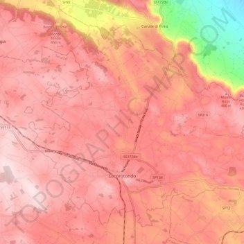
Name: Locorotondo topographic map, elevation, terrain.

Location: Locorotondo, Bari, Apulia, Italy (40.73620 17.27834 40.81117 17.39967)

Average elevation: 352 m

Minimum elevation: 95 m

Maximum elevation: 445 m

Other topographic maps

Click on a map to view its topography, its elevation and its terrain.

Impalata

Italy > Apulia > Bari > Monopoli

Average elevation: 269 m

Impalata

Italy > Apulia > Bari > Monopoli

Average elevation: 269 m

Altamura

Italy > Apulia > Bari > Altamura

Average elevation: 409 m

Polignano a Mare

Italy > Apulia > Bari

Average elevation: 42 m

Monte Belvedere

Italy > Apulia > Bari > Altamura

Average elevation: 456 m

Gear up for your next adventure:

🔪Outdoor Multitool - Versatile tool for repairs and food prep in the wild
⛺Lightweight Backpacking Tent - Compact tent for efficient hiking trips
🏕️Camping Hammock - Integrated protection for sleeping between trees
🧦Merino Wool Socks - Moisture-wicking comfort for long-distance hiking
🦶Hiking Shoe Insoles - Added support for high arches and long days on feet

As an Amazon Associate, this site earns from qualifying purchases at no extra cost to you.