
Howe Sound topographic map
Click on the map to display elevation.
About this map
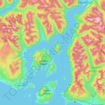
Name: Howe Sound topographic map, elevation, terrain.
Average elevation: 529 m
Minimum elevation: -2 m
Maximum elevation: 1,945 m
Sunshine Coast Regional District trails, hiking, mountain biking, running and outdoor activities
Other topographic maps
Click on a map to view its topography, its elevation and its terrain.
Langdale
Canada > British Columbia > Sunshine Coast Regional District > Area F (West Howe Sound)
Average elevation: 55 m
Mount Artaban
Canada > British Columbia > Sunshine Coast Regional District > Area F (West Howe Sound)
Average elevation: 177 m
Highest Peak
Canada > British Columbia > Sunshine Coast Regional District > Area F (West Howe Sound) > Plumper Cove
Average elevation: 42 m
Langdale
Canada > British Columbia > Sunshine Coast Regional District > Area F (West Howe Sound)
Average elevation: 55 m