Geolocate

Bueno topographic map

Click on the map to display elevation.

About this map

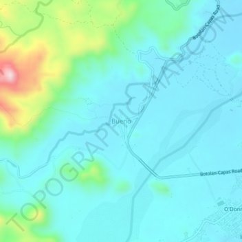
Name: Bueno topographic map, elevation, terrain.

Location: Bueno, Capas, Tarlac, Central Luzon, Philippines (15.34645 120.41972 15.38645 120.45972)

Average elevation: 176 m

Minimum elevation: 111 m

Maximum elevation: 474 m

Other topographic maps

Click on a map to view its topography, its elevation and its terrain.

Tambo Lake

Philippines > Tarlac > Capas

Average elevation: 292 m

O' Donnel River

Philippines > Tarlac > Capas

Average elevation: 222 m

Gear up for your next adventure:

🍽️Titanium Camping Spork - Ultralight and indestructible eating utensil
🧭Orienteering Kit - Tools for map reading and navigation in the wild
🧥Waterproof Pants - Keep dry during rainy hiking conditions
🥾Mountain Trail Shoes - High-traction shoes for mountain trails
🏃Hydration Running Vest - Carry water and maps close to your body for speed

As an Amazon Associate, this site earns from qualifying purchases at no extra cost to you.