Geolocate

Colditz topographic map

Click on the map to display elevation.

About this map

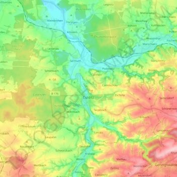
Name: Colditz topographic map, elevation, terrain.

Location: Colditz, Landkreis Leipzig, Saxony, 04680, Germany (51.09125 12.67475 51.18153 12.89833)

Average elevation: 200 m

Minimum elevation: 128 m

Maximum elevation: 309 m

Other topographic maps

Click on a map to view its topography, its elevation and its terrain.

Oellschütz

Germany > Saxony > Landkreis Leipzig > Groitzsch > Hohendorf

Average elevation: 138 m

Gear up for your next adventure:

🧊Portable Cooler - Keep food and drinks cold during outdoor adventures
🥫Freeze-Dried Meals - Lightweight, high-calorie nutrition for multi-day treks
🧦Outdoor Socks - Durable socks designed for hiking and outdoor sports
🧢Hiking Sun Hat - Wide-brimmed protection for exposed mountain ridges
💧Hydration Pack - Hands-free hydration system for long hikes

As an Amazon Associate, this site earns from qualifying purchases at no extra cost to you.