Geolocate

Cidáns topographic map

Click on the map to display elevation.

About this map

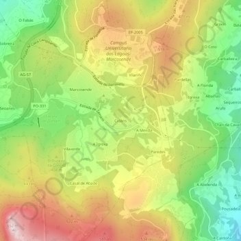
Name: Cidáns topographic map, elevation, terrain.

Location: Cidáns, Zamáns, Vigo, Pontevedra, Galicia, 36310, España (42.13814 -8.70286 42.17814 -8.66286)

Average elevation: 372 m

Minimum elevation: 88 m

Maximum elevation: 685 m

Other topographic maps

Click on a map to view its topography, its elevation and its terrain.

Islas Cíes

España > Galicia > Vigo > Vigo

Average elevation: 3 m

Navia

España > Galicia > Vigo > Vigo

Average elevation: 20 m

Zamáns

España > Galicia > Vigo > Vigo

Average elevation: 397 m

Beade

España > Galicia > Vigo > Vigo

Average elevation: 187 m

Sárdoma

España > Galicia > Vigo > Vigo

Average elevation: 64 m

Illas Cíes

España > Galicia > Vigo > Vigo

Average elevation: 3 m

Coruxo

España > Galicia > Vigo > Vigo

Average elevation: 129 m

Candeán

España > Galicia > Vigo > Vigo

Average elevation: 266 m

Candeán

España > Galicia > Vigo > Vigo

Average elevation: 240 m

Gear up for your next adventure:

💡LED Camping Lantern - Illuminate your campsite with long-lasting lanterns
🧴Sunscreen SPF - Broad-spectrum sunscreen for outdoor activities
💡Portable Camping Lamp - Rechargeable lamp for campsite lighting
🪜Heavy Duty Carabiners - Multi-use clips for securing gear to your backpack
🥾Trekking Boots - Durable boots for long-distance trekking

As an Amazon Associate, this site earns from qualifying purchases at no extra cost to you.