Geolocate

Leyburn topographic map

Click on the map to display elevation.

About this map
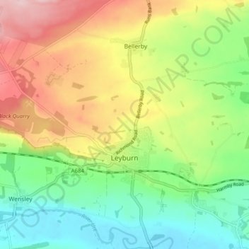
Name: Leyburn topographic map, elevation, terrain.

Location: Leyburn, North Yorkshire, England, United Kingdom (54.29398 -1.88116 54.33917 -1.80842)

Average elevation: 195 m

Minimum elevation: 100 m

Maximum elevation: 327 m

Other topographic maps

Click on a map to view its topography, its elevation and its terrain.

Sutton Bank

United Kingdom > England > North Yorkshire

Average elevation: 240 m

Runswick Bay

United Kingdom > England > North Yorkshire

Average elevation: 68 m

Womersley

United Kingdom > England > North Yorkshire

Average elevation: 17 m

Great Ayton

United Kingdom > England > North Yorkshire

Average elevation: 172 m

Nawton

United Kingdom > England > North Yorkshire

Average elevation: 79 m

Kirby Hill

United Kingdom > England > North Yorkshire

Average elevation: 196 m

Botton

United Kingdom > England > North Yorkshire

Average elevation: 284 m

Nappa

United Kingdom > England > North Yorkshire > Halton West

Average elevation: 154 m

Speeton

United Kingdom > England > North Yorkshire

Average elevation: 71 m

Glusburn

United Kingdom > England > North Yorkshire

Average elevation: 175 m

Street

United Kingdom > England > North Yorkshire > Glaisdale

Average elevation: 205 m

Holmehead

United Kingdom > England > North Yorkshire > Langcliffe

Average elevation: 256 m

Bainbridge

United Kingdom > England > North Yorkshire

Average elevation: 290 m

Thixendale

United Kingdom > England > North Yorkshire

Average elevation: 186 m

Gear up for your next adventure:

🛶Kayak Dry Bag - Waterproof storage for kayaking adventures
🌬️Windproof Camp Stove - Efficient cooking even on exposed mountain peaks
🥾Waterproof Hiking Shoes - Durable shoes for wet and rugged trails
🥾Hiking Shoes - Durable and comfortable shoes for trail hiking
🛶Canoe Life Vest - Safety vest for water sports

As an Amazon Associate, this site earns from qualifying purchases at no extra cost to you.