Geolocate

Supersaxel topographic map

Click on the map to display elevation.

About this map

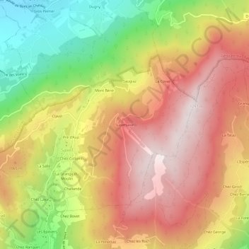
Name: Supersaxel topographic map, elevation, terrain.

Location: Supersaxel, Saxel, Thonon-les-Bains, Haute-Savoie, Auvergne-Rhône-Alpes, France métropolitaine, 74420, France (46.22716 6.38877 46.26716 6.42877)

Average elevation: 963 m

Minimum elevation: 553 m

Maximum elevation: 1,289 m

Other topographic maps

Click on a map to view its topography, its elevation and its terrain.

Gear up for your next adventure:

Tent Footprint - Protect tent floor and increase durability
Camping Groundsheet - Protect your tent from moisture and dirt
🥾Hiking Boots - Sturdy boots providing ankle support and traction on rugged trails
🦶Anti-Blister Balm - Prevents friction and hotspots during long ascents
🥾Trail Running Shoes - Lightweight and durable shoes for trail running

As an Amazon Associate, this site earns from qualifying purchases at no extra cost to you.