Geolocate

San Isidro topographic map

Click on the map to display elevation.

About this map

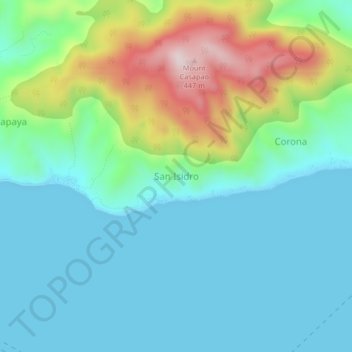
Name: San Isidro topographic map, elevation, terrain.

Location: San Isidro, Tingloy, Batangas, Calabarzon, Philippines (13.60897 120.89119 13.64897 120.93119)

Average elevation: 111 m

Minimum elevation: 0 m

Maximum elevation: 447 m

Gear up for your next adventure:

🥾Trail Hiking Boots - Supportive boots for rough trails
👖Convertible Hiking Pants - Zip-off legs to adapt to changing weather conditions
🎒Backpack Rain Cover - External shield to keep your entire pack dry
📷Outdoor Action Camera - Capture high-elevation views and rugged adventures
Backpacking Tent - Lightweight tent for long-distance hiking trips

As an Amazon Associate, this site earns from qualifying purchases at no extra cost to you.