
Make a donation
Gear up for your next adventure:
As an Amazon Associate, this site earns from qualifying purchases at no extra cost to you.
Bad Ragaz topographic map
Click on the map to display elevation.
Make a donation
Gear up for your next adventure:
As an Amazon Associate, this site earns from qualifying purchases at no extra cost to you.
Bad Ragaz
Für die Normalperiode 1991–2020 beträgt die Jahresmitteltemperatur 10,3 °C, wobei im Januar mit 1,1 °C die kältesten und im Juli mit 19,1 °C die wärmsten Monatsmitteltemperaturen gemessen werden. Im Mittel sind hier rund 77 Frosttage und 14 bis 15 Eistage zu erwarten. Sommertage gibt es im Jahresmittel rund 50, während im Schnitt knapp 10 Hitzetage zu verzeichnen sind. Die MeteoSchweiz-Wetterstation liegt auf einer Höhe von 496 m ü. M.
Make a donation
Gear up for your next adventure:
As an Amazon Associate, this site earns from qualifying purchases at no extra cost to you.
About this map
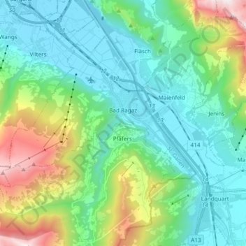
Name: Bad Ragaz topographic map, elevation, terrain.
Location: Bad Ragaz, Wahlkreis Sarganserland, St. Gallen, 7310, Schweiz (46.96060 9.39780 47.03358 9.54558)
Average elevation: 951 m
Minimum elevation: 479 m
Maximum elevation: 2,420 m
Make a donation
Gear up for your next adventure:
As an Amazon Associate, this site earns from qualifying purchases at no extra cost to you.
Other topographic maps
Click on a map to view its topography, its elevation and its terrain.
Make a donation
Gear up for your next adventure:
As an Amazon Associate, this site earns from qualifying purchases at no extra cost to you.
Schwendi im Weisstannental
Schweiz > St. Gallen > Wahlkreis Sarganserland > Mels
Average elevation: 1,441 m
Make a donation
Gear up for your next adventure:
As an Amazon Associate, this site earns from qualifying purchases at no extra cost to you.
Make a donation
Gear up for your next adventure:
As an Amazon Associate, this site earns from qualifying purchases at no extra cost to you.