Sky Valley topographic map
Interactive map
Click on the map to display elevation.
About this map
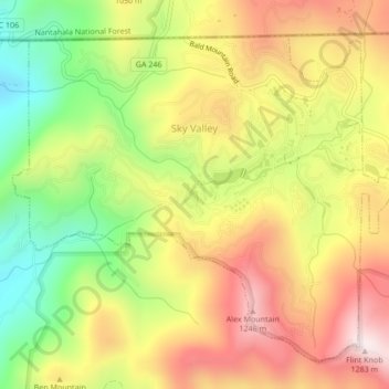
Name: Sky Valley topographic map, elevation, terrain.
Location: Sky Valley, Rabun County, Georgia, 30537, United States (34.96659 -83.35311 34.99589 -83.31062)
Average elevation: 973 m
Minimum elevation: 652 m
Maximum elevation: 1,275 m
According to the United States Census Bureau, the city has a total area of 3.0 square miles (7.8 km2), all land. The elevation of the valley floor is approximately 3100 feet above sea level, while areas within the city limits on the slopes of Rabun Bald exceed 4200 feet. Sky Valley is Georgia's highest incorporated city and one of the highest municipalities in the eastern United States.
Other topographic maps
Click on a map to view its topography, its elevation and its terrain.
Mountain City
United States > Georgia > Rabun County
Mountain City, Rabun County, Georgia, 30562, United States
Average elevation: 747 m
Chestnut Mountain
United States > Georgia > Rabun County
Chestnut Mountain, Rabun County, Georgia, 30537, United States
Average elevation: 834 m
Clayton
United States > Georgia > Rabun County
Clayton, Rabun County, Georgia, 30525, United States
Average elevation: 621 m
Elisha Mountain
United States > Georgia > Rabun County
Elisha Mountain, Rabun County, Georgia, 30525, United States
Average elevation: 828 m
Lake Burton
United States > Georgia > Rabun County
Lake Burton, Rabun County, Georgia, United States
Average elevation: 662 m
Blalock
United States > Georgia > Rabun County
Blalock, Rabun County, Georgia, United States
Average elevation: 682 m
Black Rock Mountain State Park
United States > Georgia > Rabun County > Mountain City
Black Rock Mountain State Park, Mountain City, Rabun County, Georgia, United States
Average elevation: 833 m
Tallulah Gorge State Park
United States > Georgia > Rabun County > Tallulah Falls
Tallulah Gorge State Park, Tallulah Falls, Rabun County, Georgia, United States
Average elevation: 435 m
Tallulah Gorge
United States > Georgia > Rabun County > Tallulah Falls
Tallulah Gorge, Tallulah Falls, Rabun County, Georgia, United States
Average elevation: 465 m
Lakemont
United States > Georgia > Rabun County
Lakemont, Rabun County, Georgia, 30581, United States
Average elevation: 547 m
Dillard
United States > Georgia > Rabun County
Dillard, Rabun County, Georgia, United States
Average elevation: 691 m
Rabun Gap Nacoochee School Lake
United States > Georgia > Rabun County
Rabun Gap Nacoochee School Lake, Rabun County, Georgia, United States
Average elevation: 671 m
Ben Mountain
United States > Georgia > Rabun County
Ben Mountain, Rabun County, Georgia, 30537, United States
Average elevation: 866 m
Rabun Gap Nacoochee School Lake Dam
United States > Georgia > Rabun County
Rabun Gap Nacoochee School Lake Dam, Rabun County, Georgia, 30568, United States
Average elevation: 671 m
Lake Seed
United States > Georgia > Rabun County
Lake Seed, Rabun County, Georgia, United States
Average elevation: 653 m