Geolocate

Legden topographic map

Click on the map to display elevation.

About this map

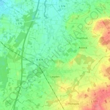
Name: Legden topographic map, elevation, terrain.

Location: Legden, Kreis Borken, North Rhine-Westphalia, 48739, Germany (52.00584 7.03927 52.09029 7.18547)

Average elevation: 74 m

Minimum elevation: 51 m

Maximum elevation: 120 m

Gear up for your next adventure:

💧Collapsible Water Bottle - Space-saving water bottle for outdoor activities
🚲MTB Frame Bag - Carry tools and maps directly on your bicycle frame
🔭Outdoor Binoculars - Lightweight binoculars for birdwatching and hiking
🧥Ultralight Puffy Jacket - Maximum warmth that packs down to the size of an orange
🧣Evaporative Cooling Towel - Beat the heat during intense summer climbs

As an Amazon Associate, this site earns from qualifying purchases at no extra cost to you.