
Hatonuevo topographic map
Click on the map to display elevation.
Hatonuevo
Hatonuevo es un municipio colombiano del departamento de La Guajira. Fue fundado el 24 de octubre de 1840 por Blas Amaya y erigido municipio en 1994. Cuenta con 24.916 habitantes (2015). Tiene una extensión territorial de 2490 km², una altitud 225 m s. n. m. y una temperatura media de 34 °C.
About this map
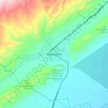
Name: Hatonuevo topographic map, elevation, terrain.
Location: Hatonuevo, Hato Nuevo, La Guajira, Colombia (11.02756 -72.80008 11.10756 -72.72008)
Average elevation: 279 m
Minimum elevation: 115 m
Maximum elevation: 775 m