
Make a donation
Gear up for your next adventure:
As an Amazon Associate, this site earns from qualifying purchases at no extra cost to you.
Glen Ridge topographic map
Click on the map to display elevation.
Make a donation
Gear up for your next adventure:
As an Amazon Associate, this site earns from qualifying purchases at no extra cost to you.
Glen Ridge
Glen Ridge has a temperate climate, with warm / hot humid summers and cool / cold winters, according to the Köppen climate classification humid subtropical climate. The town gets an average of 49 inches (1,200 mm) of rain per year and 20 inches (510 mm) of snowfall, compared to the US averages of 37 inches (940 mm) and 25 inches (640 mm) inches. Glen Ridge has 124 days of measurable precipitation a year. During the winter, it is highly recommended to wear warm clothing because it can get very cold, while the summers can get extremely hot and humid. The majority of February and a bit of March is when there are the most snowfall. Due to the town's elevation and the topography of its river banks, it is not prone to significant flooding.
Make a donation
Gear up for your next adventure:
As an Amazon Associate, this site earns from qualifying purchases at no extra cost to you.
About this map
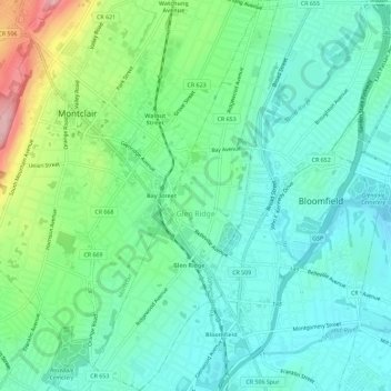
Name: Glen Ridge topographic map, elevation, terrain.
Location: Glen Ridge, Essex County, New Jersey, 07028, United States (40.78560 -74.21873 40.82900 -74.19160)
Average elevation: 71 m
Minimum elevation: 24 m
Maximum elevation: 200 m
Make a donation
Gear up for your next adventure:
As an Amazon Associate, this site earns from qualifying purchases at no extra cost to you.