Geolocate

Sector 29 topographic map

Click on the map to display elevation.

About this map

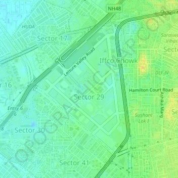
Name: Sector 29 topographic map, elevation, terrain.

Location: Sector 29, Gurgaon, Haryana, 122022, India (28.45809 77.05741 28.47806 77.07411)

Average elevation: 236 m

Minimum elevation: 225 m

Maximum elevation: 254 m

Other topographic maps

Click on a map to view its topography, its elevation and its terrain.

Badshahpur

India > Haryana > Gurgaon

Average elevation: 228 m

Damdama Lake

India > Haryana > Gurgaon

Average elevation: 242 m

Gear up for your next adventure:

🥾Mountain Trail Shoes - High-traction shoes for mountain trails
Camping Groundsheet - Protect your tent from moisture and dirt
💡Portable Camping Lamp - Rechargeable lamp for campsite lighting
🛌Insulated Sleeping Pad - Critical thermal barrier between you and the cold ground
🪜Heavy Duty Carabiners - Multi-use clips for securing gear to your backpack

As an Amazon Associate, this site earns from qualifying purchases at no extra cost to you.