
Make a donation
Gear up for your next adventure:
As an Amazon Associate, this site earns from qualifying purchases at no extra cost to you.
Khonsa topographic map
Click on the map to display elevation.
Make a donation
Gear up for your next adventure:
As an Amazon Associate, this site earns from qualifying purchases at no extra cost to you.
Khonsa
Khonsa is located at 27°01′N 95°34′E / 27.02°N 95.57°E / 27.02; 95.57. It has an average elevation of 1215 metres (3986 feet).
Make a donation
Gear up for your next adventure:
As an Amazon Associate, this site earns from qualifying purchases at no extra cost to you.
About this map
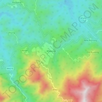
Name: Khonsa topographic map, elevation, terrain.
Location: Khonsa, Khonsa HQ, Tirap, Arunachal Pradesh, 792130, India (26.95101 95.46611 27.03101 95.54611)
Average elevation: 858 m
Minimum elevation: 383 m
Maximum elevation: 1,996 m
Make a donation
Gear up for your next adventure:
As an Amazon Associate, this site earns from qualifying purchases at no extra cost to you.