
Make a donation
Gear up for your next adventure:
As an Amazon Associate, this site earns from qualifying purchases at no extra cost to you.
Beaulieu topographic map
Click on the map to display elevation.
Make a donation
Gear up for your next adventure:
As an Amazon Associate, this site earns from qualifying purchases at no extra cost to you.
About this map
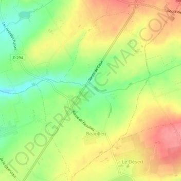
Name: Beaulieu topographic map, elevation, terrain.
Average elevation: 147 m
Minimum elevation: 104 m
Maximum elevation: 186 m
Make a donation
Gear up for your next adventure:
As an Amazon Associate, this site earns from qualifying purchases at no extra cost to you.
Other topographic maps
Click on a map to view its topography, its elevation and its terrain.
Le Moulin Pinel
France > Normandie > Calvados > Souleuvre-en-Bocage > Le Tourneur
Average elevation: 169 m
Les Blanches Landes
France > Normandie > Calvados > Souleuvre-en-Bocage > Saint-Martin-des-Besaces
Average elevation: 181 m
Make a donation
Gear up for your next adventure:
As an Amazon Associate, this site earns from qualifying purchases at no extra cost to you.
Trompe-Souris
France > Normandie > Calvados > Souleuvre-en-Bocage > Saint-Pierre-Tarentaine
Average elevation: 228 m
La Route
France > Normandie > Calvados > Souleuvre-en-Bocage > Saint-Martin-des-Besaces
Average elevation: 232 m
Make a donation
Gear up for your next adventure:
As an Amazon Associate, this site earns from qualifying purchases at no extra cost to you.
La Bistière
France > Normandie > Calvados > Souleuvre-en-Bocage > La Graverie
Average elevation: 141 m
Make a donation
Gear up for your next adventure:
As an Amazon Associate, this site earns from qualifying purchases at no extra cost to you.