Geolocate

Cabadiangan topographic map

Click on the map to display elevation.

About this map

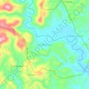
Name: Cabadiangan topographic map, elevation, terrain.

Location: Cabadiangan, Cebu, Central Visayas, 6003, Philippines (10.42548 123.94915 10.46548 123.98915)

Average elevation: 94 m

Minimum elevation: 6 m

Maximum elevation: 278 m

Gear up for your next adventure:

🧢Outdoor Cap - Protective cap for sun and rain during hikes
🔦LED Headlamp - Hands-free lighting for early morning starts or late finishes
Lightweight Backpacking Tent - Compact tent for efficient hiking trips
🕶️Polarized Sunglasses - Reduces glare from snow and water at high elevations
🛏️Camping Sleeping Mat - Comfortable mats for sleeping outdoors

As an Amazon Associate, this site earns from qualifying purchases at no extra cost to you.