
Make a donation
Gear up for your next adventure:
As an Amazon Associate, this site earns from qualifying purchases at no extra cost to you.
Osor topographic map
Click on the map to display elevation.
Make a donation
Gear up for your next adventure:
As an Amazon Associate, this site earns from qualifying purchases at no extra cost to you.
Osor
Osor liegt etwa 24 Kilometer westsüdwestlich von Girona und etwa 88 Kilometer nordöstlich von Barcelona in einer Höhe von ca. 340 m. Im Norden der Gemeinde fließt der Ter.
Make a donation
Gear up for your next adventure:
As an Amazon Associate, this site earns from qualifying purchases at no extra cost to you.
About this map
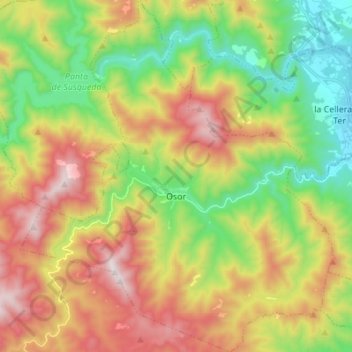
Name: Osor topographic map, elevation, terrain.
Location: Osor, la Selva, Girona, Katalonien, Spanien (41.89996 2.49628 42.00175 2.61886)
Average elevation: 584 m
Minimum elevation: 152 m
Maximum elevation: 1,161 m
Make a donation
Gear up for your next adventure:
As an Amazon Associate, this site earns from qualifying purchases at no extra cost to you.