Geolocate

Reston topographic map

Click on the map to display elevation.

About this map

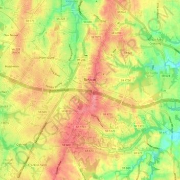
Name: Reston topographic map, elevation, terrain.

Location: Reston, Fairfax County, Virginia, United States (38.90824 -77.39326 38.99833 -77.30887)

Average elevation: 108 m

Minimum elevation: 51 m

Maximum elevation: 146 m

Other topographic maps

Click on a map to view its topography, its elevation and its terrain.

Difficult Run

United States > Virginia > Fairfax County > Reston

Average elevation: 69 m

Gear up for your next adventure:

💧Filtered Water Bottle - Safe drinking water on the go
🧤Rechargeable Heated Gloves - Extreme warmth for Canadian winter expeditions
🧥Waterproof Hiking Jacket - Protect yourself from rain and wind while hiking
🧤Insulated Winter Gloves - Heavy-duty protection for sub-zero Canadian adventures
Lightweight Backpacking Tent - Compact tent for efficient hiking trips

As an Amazon Associate, this site earns from qualifying purchases at no extra cost to you.