
Thank you for supporting this site ❤️
Make a donation
Make a donation
Gear up for your next adventure:
As an Amazon Associate, this site earns from qualifying purchases at no extra cost to you.
Leggett topographic map
Click on the map to display elevation.
Thank you for supporting this site ❤️
Make a donation
Make a donation
Gear up for your next adventure:
As an Amazon Associate, this site earns from qualifying purchases at no extra cost to you.
About this map
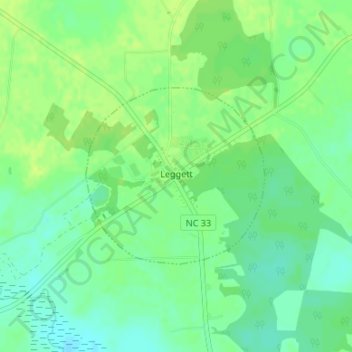
Name: Leggett topographic map, elevation, terrain.
Location: Leggett, Edgecombe County, North Carolina, United States (35.98286 -77.58857 35.99642 -77.57157)
Average elevation: 20 m
Minimum elevation: 11 m
Maximum elevation: 27 m
Thank you for supporting this site ❤️
Make a donation
Make a donation
Gear up for your next adventure:
As an Amazon Associate, this site earns from qualifying purchases at no extra cost to you.
Other topographic maps
Click on a map to view its topography, its elevation and its terrain.
Clifton Ridge
United States > North Carolina > Edgecombe County > Tarboro > Clifton Ridge
Average elevation: 28 m