Geolocate

Olga topographic map

Click on the map to display elevation.

About this map

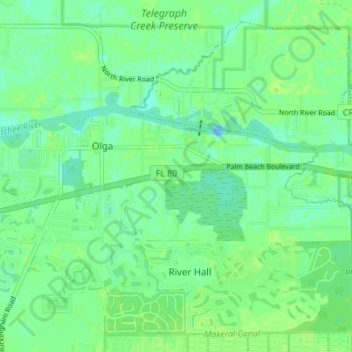
Name: Olga topographic map, elevation, terrain.

Location: Olga, Lee County, Florida, United States (26.70167 -81.72505 26.72571 -81.65600)

Average elevation: 6 m

Minimum elevation: -7 m

Maximum elevation: 10 m

Other topographic maps

Click on a map to view its topography, its elevation and its terrain.

Sanibel Island

United States > Florida > Lee County > Sanibel

Average elevation: 1 m

North Fort Myers

United States > Florida > Lee County

Average elevation: 4 m

Palmesta

United States > Florida > Lee County > Bonita Springs

Average elevation: 5 m

Bonita Springs

United States > Florida > Lee County

Average elevation: 5 m

Seasons

United States > Florida > Lee County > Bonita Springs

Average elevation: 6 m

Broken Islands

United States > Florida > Lee County

Average elevation: 2 m

Cape Coral

United States > Florida > Lee County

Average elevation: 4 m

Estero

United States > Florida > Lee County

Average elevation: 7 m

Gear up for your next adventure:

❄️Traction Ice Cleats - Slip-on spikes for icy trails and winter hiking
🔨Vehicle Emergency Tool - Safety tool for remote road trips to trailheads
🛌Insulated Sleeping Pad - Critical thermal barrier between you and the cold ground
🦌Outdoor Trail Camera - Monitor wildlife activity near your favorite spots
🥤Collapsible Travel Cup - Saves space and weight in your mess kit

As an Amazon Associate, this site earns from qualifying purchases at no extra cost to you.