Geolocate

Thames topographic map

Click on the map to display elevation.

About this map

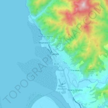
Name: Thames topographic map, elevation, terrain.

Location: Thames, Thames-Coromandel District, Waikato, New Zealand (-37.17798 175.50180 -37.09798 175.58180)

Average elevation: 102 m

Minimum elevation: -2 m

Maximum elevation: 636 m

Other topographic maps

Click on a map to view its topography, its elevation and its terrain.

Gear up for your next adventure:

🍽️Titanium Camping Spork - Ultralight and indestructible eating utensil
🗺️Topographic Maps - Detailed maps to explore trails, mountains, and wilderness areas
🧦Hiking Liner Socks - Thin base layer to prevent friction and blisters
🧭GPS Outdoor Watch - Smart watch for navigation and fitness tracking in nature
💡LED Camping Lantern - Illuminate your campsite with long-lasting lanterns

As an Amazon Associate, this site earns from qualifying purchases at no extra cost to you.