Geolocate

Sullana topographic map

Click on the map to display elevation.

About this map

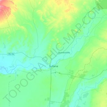
Name: Sullana topographic map, elevation, terrain.

Location: Sullana, Province of Sullana, Piura, 20100, Peru (-5.02356 -80.73713 -4.66555 -80.34710)

Average elevation: 94 m

Minimum elevation: 18 m

Maximum elevation: 413 m

Gear up for your next adventure:

🦟Insect Repellent - Keep mosquitoes and black flies away in wooded areas
🥾Hiking Boots - Sturdy boots providing ankle support and traction on rugged trails
🔥Camping Stove - Portable stoves to cook outdoors with ease
🧥Waterproof Pants - Keep dry during rainy hiking conditions
🧴Bear Spray Holster - Quick-access carry for essential Canadian wilderness safety

As an Amazon Associate, this site earns from qualifying purchases at no extra cost to you.