Geolocate

Fragagnano topographic map

Click on the map to display elevation.

About this map

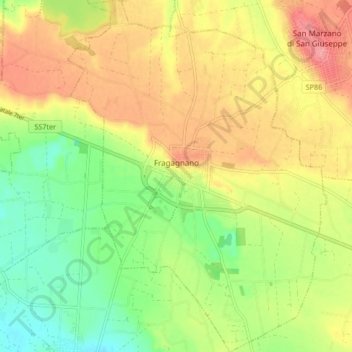
Name: Fragagnano topographic map, elevation, terrain.

Location: Fragagnano, Taranto, Apulia, 74022, Italy (40.39763 17.44643 40.46122 17.50781)

Average elevation: 97 m

Minimum elevation: 53 m

Maximum elevation: 143 m

Gear up for your next adventure:

🧰Emergency Multi-Tool - Compact multi-tool for outdoor survival
🚲Bike Repair Kit - Essential tools for on-trail mechanical issues
🔋Emergency Crank Radio - Weather alerts and power without needing batteries
🏕️Camping Hammock - Integrated protection for sleeping between trees
🔦LED Flashlight - Powerful and long-lasting flashlight for camping and emergencies

As an Amazon Associate, this site earns from qualifying purchases at no extra cost to you.