
Kalewadi topographic map
Interactive map
Click on the map to display elevation.
About this map
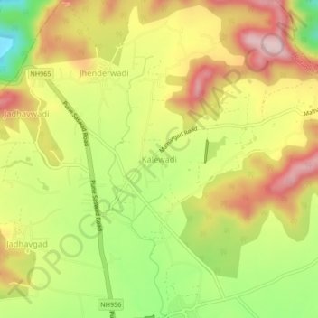
Name: Kalewadi topographic map, elevation, terrain.
Location: Kalewadi, Purandhar, Pune, Maharashtra, India (18.38436 74.00144 18.42436 74.04144)
Average elevation: 839 m
Minimum elevation: 677 m
Maximum elevation: 984 m
Other topographic maps
Click on a map to view its topography, its elevation and its terrain.
Malhargad Fort
India > Maharashtra > Purandhar
Malhargad Fort, Malhargad Walking Path, Purandhar, Pune District, Maharashtra, India
Average elevation: 822 m
Garade
India > Maharashtra > Purandhar
Garade, Purandhar, Pune, Maharashtra, 412205, India
Average elevation: 883 m
Saswad
India > Maharashtra > Purandhar
Saswad, Purandhar, Pune, Maharashtra, 412300, India
Average elevation: 787 m
Narayanpur
India > Maharashtra > Purandhar
Narayanpur, Purandhar, Maharashtra, 412302, India
Average elevation: 924 m
Jejuri
India > Maharashtra > Purandhar
Jejuri, Purandhar, Pune, Maharashtra, 412303, India
Average elevation: 728 m
Ketkawale
India > Maharashtra > Purandhar
Ketkawale, Purandhar, Pune, Maharashtra, 412302, India
Average elevation: 754 m