Geolocate

Riohacha topographic map

Click on the map to display elevation.

About this map

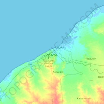
Name: Riohacha topographic map, elevation, terrain.

Location: Riohacha, La Guajira, 44001, Colombia (11.38463 -73.06698 11.70463 -72.74698)

Average elevation: 9 m

Minimum elevation: -6 m

Maximum elevation: 48 m

Other topographic maps

Click on a map to view its topography, its elevation and its terrain.

Laguna Salada

Colombia > La Guajira > Riohacha

Average elevation: 6 m

Río Ranchería

Colombia > La Guajira > Riohacha

Average elevation: 3 m

Gear up for your next adventure:

🥾Mountain Trail Shoes - High-traction shoes for mountain trails
🧴First Aid Kit - Essential first aid supplies for outdoor emergencies
🥘Camping Cookware Set - Compact nesting pots and pans for trail cooking
🧭GPS Tracker - Track your location in remote areas safely
🚲Heavy Duty Bike Lock - Secure your bike at the trailhead or during stops

As an Amazon Associate, this site earns from qualifying purchases at no extra cost to you.