Geolocate

Del Monte Forest topographic map

Click on the map to display elevation.

About this map

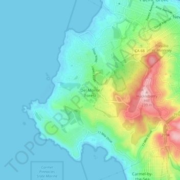
Name: Del Monte Forest topographic map, elevation, terrain.

Location: Del Monte Forest, Monterey County, California, 93953, United States (36.55396 -121.98041 36.62086 -121.91299)

Average elevation: 53 m

Minimum elevation: -5 m

Maximum elevation: 247 m

Other topographic maps

Click on a map to view its topography, its elevation and its terrain.

Laguna Seca

United States > California > Monterey County

Average elevation: 206 m

Lucia

United States > California > Monterey County > Lucia

Average elevation: 218 m

Gear up for your next adventure:

🛶Kayak Dry Bag - Waterproof storage for kayaking adventures
🥾Mountaineering Boots - Supportive boots for climbing and high-altitude hiking
🚲Handlebar Phone Mount - View topographic-map.com live while cycling
🏕️Camping Hammock - Integrated protection for sleeping between trees
🧭GPS Handheld Device - Reliable GPS navigation for outdoor adventures

As an Amazon Associate, this site earns from qualifying purchases at no extra cost to you.