Geolocate

Lucia topographic map

Click on the map to display elevation.

About this map

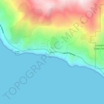
Name: Lucia topographic map, elevation, terrain.

Location: Lucia, Monterey County, California, United States (36.00079 -121.57050 36.04079 -121.53050)

Average elevation: 218 m

Minimum elevation: 0 m

Maximum elevation: 809 m

Gear up for your next adventure:

🛶Kayak Dry Bag - Waterproof storage for kayaking adventures
🧤Thermal Hiking Gloves - Grip-enhanced gloves for cold-weather altitude trekking
🔦LED Headtorch - Bright and durable light for night activities
Family Camping Tent - Spacious tent suitable for family camping trips
🧥Thermal Fleece Jacket - Versatile insulation for changing mountain temperatures

As an Amazon Associate, this site earns from qualifying purchases at no extra cost to you.