
Make a donation
Gear up for your next adventure:
As an Amazon Associate, this site earns from qualifying purchases at no extra cost to you.
Fraser's Hill topographic map
Click on the map to display elevation.
Make a donation
Gear up for your next adventure:
As an Amazon Associate, this site earns from qualifying purchases at no extra cost to you.
Fraser's Hill
Initially, Fraser was reported as having disappeared in 1910, however, the latest research by R. Hale in 2019 uncovered that he retired from his position and returned to Great Britain in 1910 and died while vacationing in Austria-Hungary in 1916. When C. J. Ferguson-Davie, the bishop of Singapore, attempted to find Fraser in 1917, he was unable to find him. Instead, he discovered the place was suitable for building a hill station as a retreat from the valley's hot climate. He wrote a report to the high commissioner and chief secretary of the Federated Malay States to suggest that a hill station be built at this location. A preliminary topographical survey was drawn up in August 1919, which confirmed the area was a suitable location for a hill station. Later, R.C.M. Kindersly, an unofficial member of the Federal Council, told the committee that it aimed to make the Fraser's Hill area a holiday resort. Construction of Fraser's Hill began in October 1919 when F.W. Mager, Pahang state engineer, surveyed the site for building construction and cleared the land around Fraser's former bungalow to build a road from The Gap to provide access to the hill station. The place was renamed Fraser's Hill and opened to visitors in 1922.
Make a donation
Gear up for your next adventure:
As an Amazon Associate, this site earns from qualifying purchases at no extra cost to you.
About this map
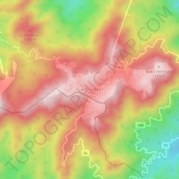
Name: Fraser's Hill topographic map, elevation, terrain.
Location: Fraser's Hill, Raub, Pahang, Malaysia (3.69305 101.71656 3.73305 101.75656)
Average elevation: 1,093 m
Minimum elevation: 760 m
Maximum elevation: 1,320 m
Make a donation
Gear up for your next adventure:
As an Amazon Associate, this site earns from qualifying purchases at no extra cost to you.
Other topographic maps
Click on a map to view its topography, its elevation and its terrain.