
Make a donation
Gear up for your next adventure:
As an Amazon Associate, this site earns from qualifying purchases at no extra cost to you.
Sidi Boutouchent topographic map
Click on the map to display elevation.
Make a donation
Gear up for your next adventure:
As an Amazon Associate, this site earns from qualifying purchases at no extra cost to you.
Sidi Boutouchent
Sidi Boutouchent, est un village situé à 1348 mètres d'altitude dans Le parc national de Theniet El Had, dans le massif de l'Ouarsenis. Sidi Boutouchent est situé à 13 km par route de la ville de sa Daïra Theniet El Had, à 180 km de la capitale Alger, et 320 km de Oran. Le mode de vie traditionnel rural perdure à Sidi Boutouchent, ancré dans la terre entre pastoralisme et récoltes au rythme des saisons. Le climat barrière sud du domaine méditerranéen, est de type humide et subhumide à hiver froid.
Make a donation
Gear up for your next adventure:
As an Amazon Associate, this site earns from qualifying purchases at no extra cost to you.
About this map
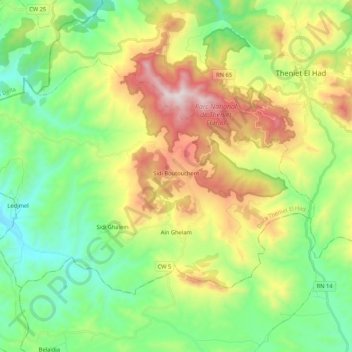
Name: Sidi Boutouchent topographic map, elevation, terrain.
Location: Sidi Boutouchent, Daïra Theniet El Had, Tissemsilt, Algérie (35.76632 1.82114 35.88106 2.03214)
Average elevation: 1,051 m
Minimum elevation: 662 m
Maximum elevation: 1,778 m
Make a donation
Gear up for your next adventure:
As an Amazon Associate, this site earns from qualifying purchases at no extra cost to you.
Other topographic maps
Click on a map to view its topography, its elevation and its terrain.
Parc National de Theniet El Had
Algérie > Tissemsilt > Daïra Theniet El Had > Theniet El Had
Average elevation: 1,293 m
Parc National de Theniet El Had
Algérie > Tissemsilt > Daïra Theniet El Had > Theniet El Had
Average elevation: 1,293 m