
Make a donation
Gear up for your next adventure:
As an Amazon Associate, this site earns from qualifying purchases at no extra cost to you.
Lac Waswanipi topographic map
Click on the map to display elevation.
Make a donation
Gear up for your next adventure:
As an Amazon Associate, this site earns from qualifying purchases at no extra cost to you.
About this map
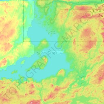
Name: Lac Waswanipi topographic map, elevation, terrain.
Average elevation: 296 m
Minimum elevation: 262 m
Maximum elevation: 378 m
Make a donation
Gear up for your next adventure:
As an Amazon Associate, this site earns from qualifying purchases at no extra cost to you.
Other topographic maps
Click on a map to view its topography, its elevation and its terrain.
Monts Otish
Canada > Québec > Jamésie > Eeyou Istchee Baie-James
La région est caractérisée par un relief de cuestas orientés d'est en ouest et dont les fronts, les versants raides, font face au nord. Elle constitue un plateau tabulaire d'altitude moyenne de 750 m. Plusieurs rivières importantes prennent leur source à cet endroit. Elles coulent principalement vers…
Average elevation: 926 m
Make a donation
Gear up for your next adventure:
As an Amazon Associate, this site earns from qualifying purchases at no extra cost to you.