Geolocate

Lamjile topographic map

Click on the map to display elevation.

About this map

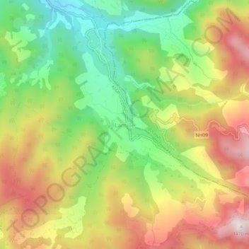
Name: Lamjile topographic map, elevation, terrain.

Location: Lamjile, Alital, Dadeldhura, Sudurpashchim Province, Nepal (29.06994 80.50980 29.10994 80.54980)

Average elevation: 1,052 m

Minimum elevation: 708 m

Maximum elevation: 1,441 m

Other topographic maps

Click on a map to view its topography, its elevation and its terrain.

Ganayapdhura

Nepal > Sudurpashchim Province > Dadeldhura

Average elevation: 1,711 m

Bhageshwar

Nepal > Sudurpashchim Province > Dadeldhura

Average elevation: 1,317 m

Gear up for your next adventure:

🧦Crew Hiking Socks - Comfortable socks for long-distance hikes
🔭Outdoor Binoculars - Lightweight binoculars for birdwatching and hiking
🪑Insulated Seat Pad - Protect your seat from cold rocks and wet logs
🥾Mountain Trail Shoes - High-traction shoes for mountain trails
🛶Kayak Dry Bag - Waterproof storage for kayaking adventures

As an Amazon Associate, this site earns from qualifying purchases at no extra cost to you.