
Make a donation
Gear up for your next adventure:
As an Amazon Associate, this site earns from qualifying purchases at no extra cost to you.
Polientes topographic map
Click on the map to display elevation.
Make a donation
Gear up for your next adventure:
As an Amazon Associate, this site earns from qualifying purchases at no extra cost to you.
Polientes
Polientes es la capital del municipio de Valderredible. Está situada a 112 kilómetros de Santander, y tiene una altitud de 715 m s. n. m.. En el año 2012, Polientes contaba con una población de 228 habitantes (INE). Posee numerosas instalaciones de hostelería así como de hospedaje.
Make a donation
Gear up for your next adventure:
As an Amazon Associate, this site earns from qualifying purchases at no extra cost to you.
About this map
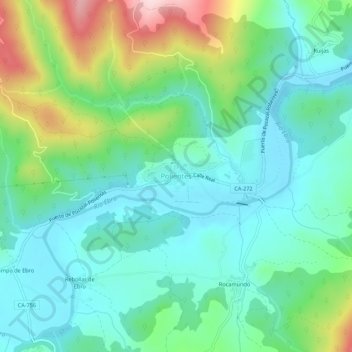
Name: Polientes topographic map, elevation, terrain.
Location: Polientes, Valderredible, Cantabria, 39220, España (42.78585 -3.96075 42.82585 -3.92075)
Average elevation: 770 m
Minimum elevation: 690 m
Maximum elevation: 987 m
Make a donation
Gear up for your next adventure:
As an Amazon Associate, this site earns from qualifying purchases at no extra cost to you.
Other topographic maps
Click on a map to view its topography, its elevation and its terrain.