Geolocate

Baleendah topographic map

Click on the map to display elevation.

About this map

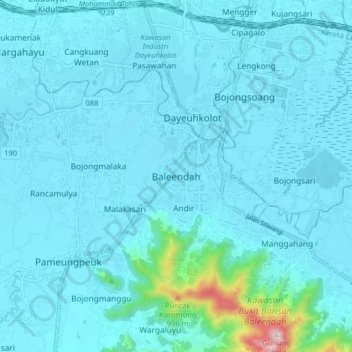
Name: Baleendah topographic map, elevation, terrain.

Location: Baleendah, Kabupaten Bandung, Java, 40288, Indonesia (-7.03996 107.58087 -6.95996 107.66087)

Average elevation: 690 m

Minimum elevation: 656 m

Maximum elevation: 1,114 m

Other topographic maps

Click on a map to view its topography, its elevation and its terrain.

Soreang

Indonesia > Kabupaten Bandung

Average elevation: 745 m

Gear up for your next adventure:

🌬️Windproof Camp Stove - Efficient cooking even on exposed mountain peaks
Bushcraft Tarp - Versatile emergency shelter or gear protection
🥾Trail Running Boots - Durable shoes designed for trail running
🧊Insulated Water Bottle - Keeps drinks cold in summer and prevents freezing in winter
🥾Mountain Hiking Shoes - Shoes with superior grip for mountainous terrain

As an Amazon Associate, this site earns from qualifying purchases at no extra cost to you.