Geolocate

New Canipo topographic map

Click on the map to display elevation.

About this map

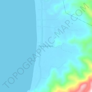
Name: New Canipo topographic map, elevation, terrain.

Location: New Canipo, Roxas, Palawan, Mimaropa, Philippines (10.69599 119.32748 10.73599 119.36748)

Average elevation: 36 m

Minimum elevation: -1 m

Maximum elevation: 422 m

Other topographic maps

Click on a map to view its topography, its elevation and its terrain.

Long Beach

Philippines > Palawan > Roxas > San Isidro

Average elevation: 4 m

Purao Island

Philippines > Palawan > Roxas

Average elevation: 0 m

Stanlake Island

Philippines > Palawan > Roxas

Average elevation: 0 m

Coconut Beach

Philippines > Palawan > Roxas

Average elevation: 23 m

Boayan

Philippines > Palawan > Roxas

Average elevation: 12 m

Gear up for your next adventure:

Camping Coffee Maker - Brew fresh coffee anywhere on the topographic map
🧥Waterproof Pants - Keep dry during rainy hiking conditions
🥾Hiking Gaiters - Protect legs and shoes from mud, snow, and debris
🔭Compact Binoculars - Lightweight optics for scouting trails and wildlife
🥾Light Trekking Boots - Supportive boots for multi-day treks

As an Amazon Associate, this site earns from qualifying purchases at no extra cost to you.