
Make a donation
Gear up for your next adventure:
As an Amazon Associate, this site earns from qualifying purchases at no extra cost to you.
Winthrop Glacier topographic map
Click on the map to display elevation.
Make a donation
Gear up for your next adventure:
As an Amazon Associate, this site earns from qualifying purchases at no extra cost to you.
Winthrop Glacier
The Winthrop Glacier is a large glacier on the northeastern side of Mount Rainier in Washington. Named after Theodore Winthrop, the body of ice covers 3.5 mile2 (9.1 km2) and has a volume of 18.5 billion feet3 (523 million m3). Starting at over 14,300 feet (4,400 m) at the Columbia Crest, the glacier heads north and descends steeply over the uneven topography of Rainier. Another glacier, the Emmons Glacier is directly connected to this glacier up to the Steamboat Prow. After passing the Prow, the glaciers split up; the Emmons heads east-northeastward and the Winthrop continues northeast. As the terrain becomes flatter, the Winthrop glacier becomes heavily rock-covered when it terminates in a forest at about 4,900 ft (1,500 m). Meltwater from the glacier drains into the White River.
Make a donation
Gear up for your next adventure:
As an Amazon Associate, this site earns from qualifying purchases at no extra cost to you.
About this map
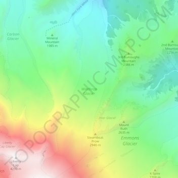
Name: Winthrop Glacier topographic map, elevation, terrain.
Location: Winthrop Glacier, Pierce County, Washington, United States (46.85356 -121.76272 46.92159 -121.72429)
Average elevation: 2,404 m
Minimum elevation: 1,463 m
Maximum elevation: 4,364 m
Make a donation
Gear up for your next adventure:
As an Amazon Associate, this site earns from qualifying purchases at no extra cost to you.
Other topographic maps
Click on a map to view its topography, its elevation and its terrain.
Mount Rainier
United States > Washington > Pierce County
Mount Rainier (/reɪˈnɪər/), indigenously known as Tahoma, Tacoma, Tacobet, or təqʷubəʔ, is a large active stratovolcano in the Cascade Range of the Pacific Northwest, located in Mount Rainier National Park about 59 miles (95 km) south-southeast of Seattle. With a summit elevation of 14,411 ft (4,392…
Average elevation: 3,911 m
Make a donation
Gear up for your next adventure:
As an Amazon Associate, this site earns from qualifying purchases at no extra cost to you.
Make a donation
Gear up for your next adventure:
As an Amazon Associate, this site earns from qualifying purchases at no extra cost to you.
Gig Harbor
United States > Washington > Pierce County > Gig Harbor > Gig Harbor
Average elevation: 49 m
Mount Rainier
United States > Washington > Pierce County
Mount Rainier (/reɪˈnɪər/ ray-NEER), also known as Tahoma, is a large active stratovolcano in the Cascade Range of the Pacific Northwest in the United States. The mountain is located in Mount Rainier National Park about 59 miles (95 km) south-southeast of Seattle. With an officially recognized summit…
Average elevation: 3,911 m
Make a donation
Gear up for your next adventure:
As an Amazon Associate, this site earns from qualifying purchases at no extra cost to you.
Make a donation
Gear up for your next adventure:
As an Amazon Associate, this site earns from qualifying purchases at no extra cost to you.
Mount Rainier
United States > Washington > Pierce County
Mount Rainier (/reɪˈnɪər/ ray-NEER), also known as Tahoma, is a large active stratovolcano in the Cascade Range of the Pacific Northwest in the United States. The mountain is located in Mount Rainier National Park about 59 miles (95 km) south-southeast of Seattle. With a summit elevation of 14,411 ft…
Average elevation: 3,911 m
Make a donation
Gear up for your next adventure:
As an Amazon Associate, this site earns from qualifying purchases at no extra cost to you.
Make a donation
Gear up for your next adventure:
As an Amazon Associate, this site earns from qualifying purchases at no extra cost to you.
Make a donation
Gear up for your next adventure:
As an Amazon Associate, this site earns from qualifying purchases at no extra cost to you.
Make a donation
Gear up for your next adventure:
As an Amazon Associate, this site earns from qualifying purchases at no extra cost to you.