Geolocate

Provincia de Chota topographic map

Click on the map to display elevation.

About this map

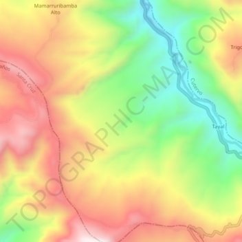
Name: Provincia de Chota topographic map, elevation, terrain.

Location: Provincia de Chota, Cochabamba, Chota, Cajamarca, Perú (-6.55533 -78.82459 -6.51533 -78.78459)

Average elevation: 2,316 m

Minimum elevation: 1,941 m

Maximum elevation: 2,680 m

Other topographic maps

Click on a map to view its topography, its elevation and its terrain.

Llanduma

Perú > Cajamarca > Cochabamba

Average elevation: 1,977 m

Sogos

Perú > Cajamarca > Cochabamba

Average elevation: 2,321 m

Salabamba

Perú > Cajamarca > Cochabamba

Average elevation: 2,656 m

Gear up for your next adventure:

🧦Thermal Socks - Warm socks for winter hiking or camping
🧢Beanie Hat - Keep your head warm in cold weather
🏕️Camping Hammock - Integrated protection for sleeping between trees
🧥Packable Rain Jacket - Breathable waterproof layer for unpredictable weather
🧥Softshell Jacket - Windproof and breathable jacket for hiking

As an Amazon Associate, this site earns from qualifying purchases at no extra cost to you.