
Make a donation
Gear up for your next adventure:
As an Amazon Associate, this site earns from qualifying purchases at no extra cost to you.
Nowy Targ topographic map
Click on the map to display elevation.
Make a donation
Gear up for your next adventure:
As an Amazon Associate, this site earns from qualifying purchases at no extra cost to you.
Nowy Targ
Nowy Targ is located in the heart of Podhale (one of the Goral Lands) at the altitude of 585–850 m above sea level (AMSL); latitude 49°28' N, longitude 20°01' E. Distance to the main urban agglomerations in Poland is: Warsaw – 376 km (234 mi), Łódź – 348 km (216 mi), Kraków – 84 km (52 mi), Gdańsk – 690 km (429 mi), Wrocław – 346 km (215 mi), Katowice – 157 km (98 mi), Kielce – 200 km (124 mi), Rzeszów – 214 km (133 mi), Szczecin – 727 km (452 mi), Białystok - 574 km (357 mi), Poznań – 475 km (295 mi), Częstochowa – 226 km (140 mi), Słupsk – 759 km (472 mi).
Make a donation
Gear up for your next adventure:
As an Amazon Associate, this site earns from qualifying purchases at no extra cost to you.
About this map
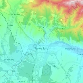
Name: Nowy Targ topographic map, elevation, terrain.
Location: Nowy Targ, Nowy Targ County, Lesser Poland Voivodeship, Poland (49.44404 19.98251 49.53448 20.10343)
Average elevation: 676 m
Minimum elevation: 567 m
Maximum elevation: 1,135 m
Make a donation
Gear up for your next adventure:
As an Amazon Associate, this site earns from qualifying purchases at no extra cost to you.