Geolocate

Krvavec topographic map

Click on the map to display elevation.

About this map

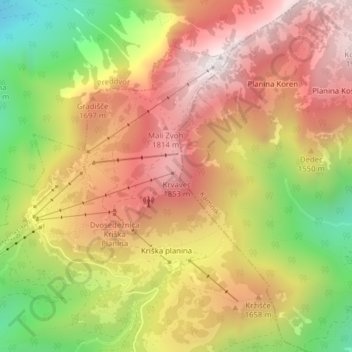
Name: Krvavec topographic map, elevation, terrain.

Location: Krvavec, Cerklje na Gorenjskem, Slovenia (46.29963 14.53670 46.29973 14.53680)

Average elevation: 1,500 m

Minimum elevation: 916 m

Maximum elevation: 1,957 m

Gear up for your next adventure:

🧴Bear Spray Holster - Quick-access carry for essential Canadian wilderness safety
🌡️Emergency Mylar Blankets - Compact thermal protection for unexpected nights outdoors
🥾Trail Running Shoes - Lightweight and durable shoes for trail running
🧢Beanie Hat - Keep your head warm in cold weather
👟Trail Running Shoes - Agile footwear for fast-paced topographic exploration

As an Amazon Associate, this site earns from qualifying purchases at no extra cost to you.