
Muzaffarabad topographic map
Interactive map
Click on the map to display elevation.
About this map
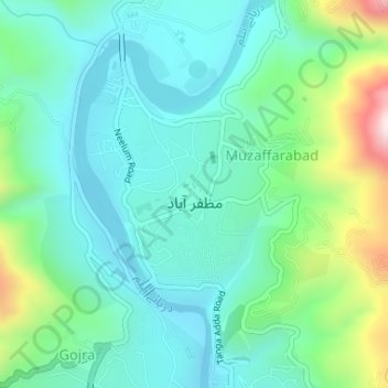
Name: Muzaffarabad topographic map, elevation, terrain.
Location: Muzaffarabad, ضلع مظفر آباد, Asad Kaschmir, Pakistan (34.36595 73.46108 34.38205 73.47554)
Average elevation: 793 m
Minimum elevation: 668 m
Maximum elevation: 1,184 m
Other topographic maps
Click on a map to view its topography, its elevation and its terrain.
lass
Pakistan > Asad Kaschmir > Distrikt Bhimber > Bhimber
lass, Bhimber, Distrikt Bhimber, میرپور ڈویژن, Asad Kaschmir, Pakistan
Average elevation: 341 m