Geolocate

Dearborn topographic map

Click on the map to display elevation.

About this map

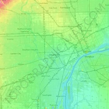
Name: Dearborn topographic map, elevation, terrain.

Location: Dearborn, Wayne County, Michigan, 48126, United States (42.16226 -83.33631 42.48226 -83.01631)

Average elevation: 190 m

Minimum elevation: 169 m

Maximum elevation: 259 m

Other topographic maps

Click on a map to view its topography, its elevation and its terrain.

Gear up for your next adventure:

🥾Trail Running Shoes - Lightweight and durable shoes for trail running
🧼Biodegradable Camp Soap - Environmentally friendly cleaning for gear and body
🔦UV Flashlight - Detect minerals or specific insects in the dark
🔭Compact Binoculars - Lightweight optics for scouting trails and wildlife
🐕Hiking Dog Pack - Let your canine companion carry their own water and food

As an Amazon Associate, this site earns from qualifying purchases at no extra cost to you.