
Make a donation
Gear up for your next adventure:
As an Amazon Associate, this site earns from qualifying purchases at no extra cost to you.
Kelowna topographic map
Click on the map to display elevation.
Make a donation
Gear up for your next adventure:
As an Amazon Associate, this site earns from qualifying purchases at no extra cost to you.
Kelowna
Kelowna is classified as a humid continental climate or an inland oceanic climate per the Köppen climate classification system due to its coldest month having an average temperature slightly above −3.0 °C (26.6 °F) and below 0 °C (32 °F), with dry, hot, sunny summers and cool, cloudy winters, and four seasons. The official climate station for Kelowna is at the Kelowna International Airport, which is at a higher elevation than the city core, with slightly higher precipitation and cooler nighttime temperatures. Kelowna has the second mildest winter of any non-coastal city in Canada, after neighbouring Penticton. This is caused by the moderating effects of Okanagan Lake combined with mountains separating most of BC from the prairies; however Arctic air masses do occasionally penetrate the valley during winter, usually for very short periods. The coldest recorded temperature in the city was −36.1 °C (−33.0 °F) recorded on 30 December 1968.
Make a donation
Gear up for your next adventure:
As an Amazon Associate, this site earns from qualifying purchases at no extra cost to you.
About this map
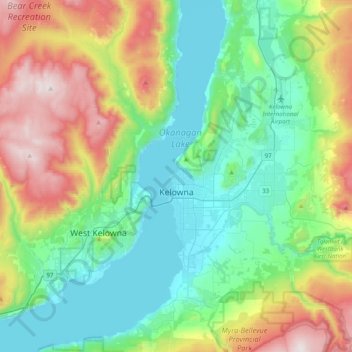
Name: Kelowna topographic map, elevation, terrain.
Average elevation: 704 m
Minimum elevation: 335 m
Maximum elevation: 1,576 m
Make a donation
Gear up for your next adventure:
As an Amazon Associate, this site earns from qualifying purchases at no extra cost to you.
Other topographic maps
Click on a map to view its topography, its elevation and its terrain.
Lake Country
Canada > British Columbia > Regional District of Central Okanagan > Lake Country > Lake Country
Average elevation: 528 m
The Commons Field
Canada > British Columbia > Regional District of Central Okanagan > Kelowna
Average elevation: 442 m
Fintry
Canada > British Columbia > Regional District of Central Okanagan > West Central Okanagan Electoral Area
Average elevation: 437 m
Pandosy
Canada > British Columbia > Regional District of Central Okanagan > Kelowna
Average elevation: 345 m
Make a donation
Gear up for your next adventure:
As an Amazon Associate, this site earns from qualifying purchases at no extra cost to you.
Terrace Mountain
Canada > British Columbia > Regional District of Central Okanagan > West Central Okanagan Electoral Area
Average elevation: 1,553 m
Mission Creek Regional Park
Canada > British Columbia > Regional District of Central Okanagan > Kelowna
Average elevation: 436 m
Oyama
Canada > British Columbia > Regional District of Central Okanagan > Lake Country
Average elevation: 481 m
West Kelowna
Canada > British Columbia > Regional District of Central Okanagan > West Kelowna
Average elevation: 871 m
Make a donation
Gear up for your next adventure:
As an Amazon Associate, this site earns from qualifying purchases at no extra cost to you.
Damer Lake
Canada > British Columbia > Regional District of Central Okanagan > East Central Okanagan Electoral Area
Average elevation: 1,353 m
Browne Lake
Canada > British Columbia > Regional District of Central Okanagan > East Central Okanagan Electoral Area
Average elevation: 1,326 m
Christie Lake
Canada > British Columbia > Regional District of Central Okanagan > West Central Okanagan Electoral Area
Average elevation: 1,448 m
Little White Mountain
Canada > British Columbia > Regional District of Central Okanagan > East Central Okanagan Electoral Area
Average elevation: 1,935 m
Make a donation
Gear up for your next adventure:
As an Amazon Associate, this site earns from qualifying purchases at no extra cost to you.
Black Knight Mountain
Canada > British Columbia > Regional District of Central Okanagan > East Central Okanagan Electoral Area
Average elevation: 992 m
Knox Mountain
Canada > British Columbia > Regional District of Central Okanagan > Kelowna
Average elevation: 430 m
Knox Mountain
Canada > British Columbia > Regional District of Central Okanagan > Kelowna
Average elevation: 430 m
Moraine Park
Canada > British Columbia > Regional District of Central Okanagan > Kelowna
Average elevation: 408 m
Make a donation
Gear up for your next adventure:
As an Amazon Associate, this site earns from qualifying purchases at no extra cost to you.
Oyama
Canada > British Columbia > Regional District of Central Okanagan > Lake Country
Average elevation: 481 m
Moraine Park
Canada > British Columbia > Regional District of Central Okanagan > Kelowna
Average elevation: 408 m